
Derby County vs Leeds United weather news as Met Office warning in place

Leeds United will visit Championship club Derby County in the FA Cup third round on Sunday - but what impact could Storm Goretti have at Pride Park?
Storm Goretti could make an impact on this weekend’s FA Cup third round fixture list as snow and plummeting temperatures continue to hit across the country.
Leeds United’s preparations for Sunday’s third round tie at former Championship rivals Derby County have been played out in freezing temperatures and there are Met Office warnings stating disruption is likely across the weekend. Much of the impact has been felt in the south of England and Wales over the last 24 hours with wind gusts reaching their highest reported levels since 1991 after a gust of 99 miles per hour was reached on the Isles of Scilly.
Fortunately, the impact of the storm will reduce throughout Friday and there is expected to be what the Met Office describe as ‘a period of respite’ on Saturday. However, another weather front is expected to arrive on Sunday and that will bring a risk of further snow and that will also bring ‘potential to be disruptive with warnings issued for this’. As it stands, there is a moderate snow and ice warning in place across the East Midlands - and although Saturday is expected to be dry, BBC Weather are reporting Derbyshire has a risk of being hit with freezing temperatures and snow and rain in the hours before Sunday’s FA Cup tie at Pride Park.
The tie is expected to go ahead and is not at risk as it stands, but the Met Office and officials at both clubs will monitor the situation in the hours before the tie.
Met Office statement
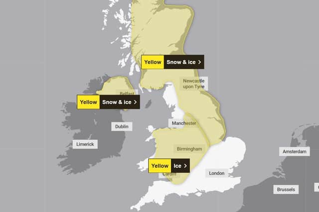

A statement released by the Met Office has warned there could be further disruption as the weekend progresses and revealed further warnings could be in place on Sunday with ‘amber cold weather health alerts’ in place across England until Monday.
In the statement, Met Office Chief Forecaster Steve Willington said: “Following on from a Saturday which will be largely dry away from northeastern parts of Scotland and England, a front from the west on Sunday will bring snow for parts of Scotland and northern England with low temperatures continuing the ice risk.
“A further 2-5cm of snow is possible to accumulate at low levels within the warning area on Sunday, with 10-20cm possible over higher ground. With much of this falling in areas that have already seen severe snowfall, ongoing disruption is likely. Those in central and southern England and Wales will see this fall as rain, in what will be a wet Sunday for many.”
The statement concluded: “Further warnings are possible for Sunday, so it’s important to stay up to date with the latest Met Office forecast. In addition to the severe weather warnings, UKHSA Amber cold weather health alerts are in place for all regions of England until 12 January.”
Your next Leeds United read: Former Leeds United star Patrick Bamford's future takes new twist