
UK weather: Wintry showers and further rain forecast for Leeds - when wintry showers are predicted for city
Watch the Met Office forecast, as further rain and even some wintry showers are predicted for the rest of the week.
After a wet and windy Tuesday in Leeds, the Met Office says Storm Chandra has now become absorbed into a mature low-pressure system to the northwest of the UK.
Fog and ice has cleared throughout today (Wednesday January 28), leaving some brighter spells and drier conditions for many.
However, further areas of low pressure will continue to track eastwards across the Atlantic through this week. These systems are set to slow as they encounter a blocking area of high pressure over eastern Europe, resulting in additional spells of rain, particularly in the southwest.
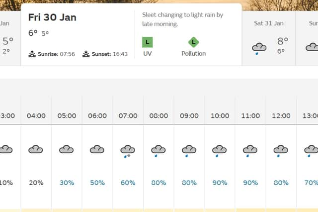

Currently, the Met Office is forecasting Leeds to see some wintry showers on Friday morning (January 30), with rain forecast for both Saturday (January 31) and Sunday (February 1).
Met Office Leeds forecast
Thursday January 29 - Overcast, top temperature 5°C, lowest temperature 2°C, highest wind gust 22mph
Friday January 30 - Sleet (forecast for 07:00) changing to light rain by late morning, 50% and over chance of precipitation all day, top temperature 6°C, lowest temperature 5°C, highest wind gust 25mph
Saturday January 31 - Light rain, 50% and over chance of precipitation all day, top temperature 8°C, lowest temperature 6°C, highest wind gust 22mph
Sunday February 1 - Light rain changing to overcast by late morning, 50% chance of precipitation until 12:00 - when it drops to 40% chance of precipitation, highest wind gust 13mph
Met Office Yorkshire and Humber weather forecast
Today (Wednesday January 28)
Areas of fog possible at first, but also some coastal mist, and low cloud obscuring upland areas. These lifting and breaking through the day, with sunny spells developing. Perhaps the odd shower moving into coastal parts later. Maximum temperature 7 °C.
Tonight (Wednesday January 28)
A few showers spreading inland overnight. Otherwise variable cloud, with frost and fog patches reforming under clearer skies. Low cloud also thickening through the night, with hill fog likely. Minimum temperature 0 °C.
Thursday (January 29)
Early low cloud, patchy fog and hill fog will be slow to clear, but with some sunny spells developing by the afternoon. Winds strengthening a little by the evening. Chilly. Maximum temperature 5 °C.
Outlook for Friday (January 30) to Sunday (February 1)
Winds strengthening overnight, with outbreaks of rain by Friday morning. Staying cloudy and breezy Saturday, with further light rain. Likely drier Sunday, with brighter spells, but still the odd shower.